Namo Nepal

Nepal E-Brochures & Interactive Route Maps for Trekking and Tours

Explore Nepal with e-Brochures & Interactive Route Maps 🗺️

Plan your perfect Nepali adventure with comprehensive digital brochures and route maps. Whether trekking the Himalayas, exploring cultural sites, or navigating cities, these downloadable guides make your journey seamless and informed.

Interactive guides and up-to-date information are essential for every traveler.

Why Use e-Brochures and Route Maps?

Instant Access

Easy digital access on smartphones and tablets, anytime, anywhere.

Simplified Navigation

Interactive maps with GPS and itinerary overlays simplify complex routes.

Offline Readiness

Downloadable and printable options for reliable offline reference.

Detailed Information

Detailed info on attractions, accommodation, and essential cultural notes.

Key Stat: Over 70% of travelers rely on digital maps and brochures for planning and navigating tours in Nepal.

Mapping Nepal's Diversity

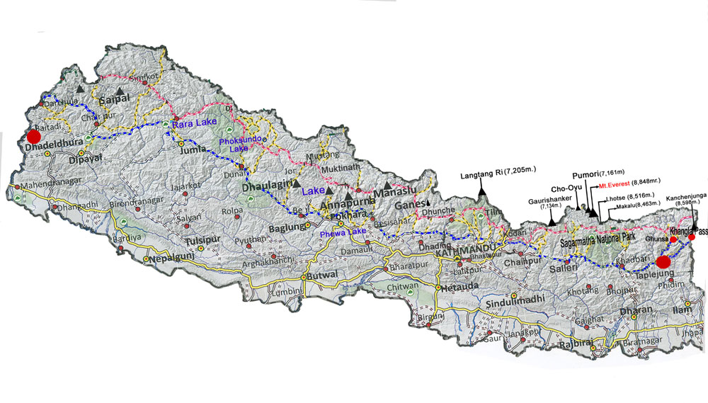
Nepal’s vast and diverse geography calls for detailed, accessible route maps and travel brochures. e-Brochures combine vibrant visuals, tour info, safety tips, and cultural notes in a single portable format.

Route maps showcase trekking paths, city landmarks, transport options, and natural features, helping travelers explore efficiently. Increasingly, these guides integrate GPS tracking, altitude profiles, and local insights, enhancing both safety and the overall experience.

A tourist actively using a digital trekking map application on a smartphone.

Feature Highlights: Guided Exploration

1. Trekking Route Maps 🏔️

Detailed GPS routes for major treks like Annapurna, Everest Base Camp, Langtang, and Upper Mustang.

2. Cultural and City Brochures 🏯

Interactive guides featuring heritage sites, markets, temples, and festival routes for major cities.

3. Transport Maps 🚌

Downloadable public transport and road maps aiding local navigation and efficient travel scheduling.

4. Eco-Tourism & Nature Trails 🌿

Maps and brochures promoting national parks, wildlife preserves, and conservation-focused zones.

5. Customizable Itineraries 📝

Tools to create and download personalized itineraries integrating route maps and destination info.

Detailed Features List

Map/Brochure Type
Features
Trekking Routes
GPS tracking, altitudes, campsites, and essential safety points.
Heritage Trails
Vibrant visuals, detailed history, and cultural insights on sites.
City Navigation
Public transport lines, major landmarks, and local dining locations.
Mobile-Friendly
Interactive functionality, GPS-enabled, and waypoint tracking support.
Printable PDFs
High-quality versions for offline access and portable, detailed text reference.

Digital Convenience for Trekking & Tours

Instant Access & Safety Features

e-Brochures offer instant updates, multimedia features, and layered information, unlike bulky paper maps. Crucially, many apps provide offline functionality, vital for high altitude or remote villages without internet connectivity.

Travelers appreciate maps that include safety alerts, detour options, health precautions, and cultural tips, enhancing both adventure and cultural immersion.

Offline Access and Security: GPS-based route tracking enhances safety, providing real-time location and reporting on changing trail conditions.

Planning & Personalized Journey

Planning Your Journey: Use route maps to accurately gauge distances, estimated trek times, and altitude gains. This makes logistics and pace planning efficient and safe.

Brochures assist with vital information like accommodation choices, dining options, and local customs, ensuring a more enjoyable experience.

Integrating Technology and Tradition: Digital brochures integrate storytelling with practical info, allowing you to discover Nepal’s historical sites and natural beauty with unparalleled context.

Plan, Explore, Enjoy 🧭

Get your customized e-brochures and detailed route maps today for a hassle-free Nepal adventure.

FAQs: Digital Travel Guides

1. Are e-brochures free?
Many official tourism brochures and basic route maps are available free online. Detailed, customized guides from private travel agencies may require a purchase.
2. Can I use route maps offline?
Yes, the major advantage of these maps is that most GPS-enabled versions offer downloadable areas for reliable use without internet access on remote treks.
3. How accurate are these maps?
Trusted operators update maps regularly, often relying on GPS data and community reports. However, it’s always wise to cross-verify key information in the field.
4. Do they include altitudes and difficulty levels?
Yes, especially trekking and hiking maps. They are crucial tools that feature detailed altitude profiles, distance markers, and route difficulty grades.
5. Can I customize itineraries with e-brochures?
Many digital guides offer tools that allow you to select points of interest, adjust daily distances, and create personalized itineraries based on your interests and timing.
6. Are cultural and festival routes covered?
Yes, many brochures often include detailed sections and maps covering major festival guides, historical routes, and culturally significant sites with timings and background.
7. How do maps help with safety?
They are essential safety tools that highlight emergency shelters, medical posts, reliable communication spots, and alert areas for geological risks like landslides or weather changes.
8. What devices support these digital maps?
The guides and maps are designed to be compatible with most smartphones and tablets that have modern operating systems, either via dedicated apps or standard PDF readers.
9. Can I print these brochures?
While primarily digital, many guides and route maps offer high-quality, optimized PDF versions that can be easily printed for a tangible backup.
10. How regularly are they updated?
Leading providers commit to updating their digital content annually or immediately after major changes to trekking routes, road networks, or national park regulations.

Navigate Nepal with Confidence 🔒

Download trusted e-brochures and route maps to explore safely and fully.

Scroll to Top